
Dolores proudly shows her ADK 46Rs certificate for climbing the 46 high peaks of the Adirondacks, sharing the moment with Joe Ryan, the ADK 46R correspondent who shepherded us through the process. Thanks to Mindaugas "Mindy" Jatulis, who took this photo during the Lake Placid ceremony in May 2010.
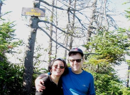
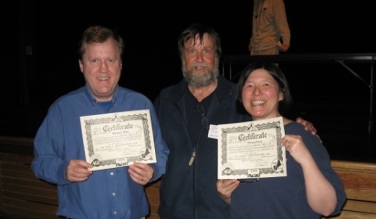

Photo by friendly park volunteer, 9/6/2005
This is the home page of our developing Internet site on Four Thousand Footers, New England's Hundred Highest, the Adirondacks 46Rs, the Northeast 111 Club and the Fire Tower Challege. It's been one of our goals (obsessions?) in life to climb lists of high peaks in the Northeast. What next?
We're both writers living in New England, and we've been hiking and backpacking together for years. We're authors of two Falcon guides, Hiking Acadia National Park and Best Easy Day Hikes, Acadia National Park. To order, link to Falcon Books, The Globe Pequot Press, Barnes & Noble, or Amazon. You can search by title, or by our names, Dolores Kong and Dan Ring. We're currently in the process of updating the first editions of the Falcon hiking guides. Dolores is also a CERTIFIED FINANCIAL PLANNER(TM) professional in Boston. You can find out more about her at www.kong.com or at www.doloreskong.com.
We've completed all 270-plus miles of the Appalachian Trail in Maine over the course of several trips, and have hiked portions of the AT in New Hampshire and Virginia. Don't know if we'll ever attempt to do the whole 2000-plus miles of the trail, however, since it's so crowded we've nicknamed it the Appalachian Highway.
Here, you'll get to monitor our progress in achieving our goal of hiking the highest mountains of the Northeast. We'll be updating this site, and adding neat features along the way (as Dolores gets better at HTML), so check back periodically!
Created by the Appalachian Mountain Club, the Four Thousand Footer Club and New England Hundred Highest Club are open to all hikers who have ascended and descended on foot each of the summits on the official lists.
First, climb the 48 Four Thousand Footers in the White Mountains of New Hampshire, to join the Four Thousand Footers Club of the White Mountains. Then climb the other 19 Four Thousand Footers in Maine and New Hampshire, to join the Four Thousand Footer Club of New England. Finally, round out the Hundred Highest with another 30-plus peaks in Maine, New Hampshire and Vermont. Some of the Hundred Highest are trailless bushwhacks.
Don't assume that every peak of 4000 feet or higher is on the official Four Thousand Footer lists, however. There's a complicated elevation gain rule that eliminates some summits. You may find yourself unnecessarily climbing a mountain if you don't check the lists first. Also, be sure to go to the official summit, and not some false peak. Finally, make sure you aren't working off an old list. Else you may find yourself climbing the 103 Highest Peaks of New England, as we did, with Mahoosuc Arm, Middle Abraham and the North Horn of Bigelow Mountain no longer making the cut with new elevation data.
For official lists, application and rules, write to the AMC Four Thousand Footer Committee, c/o Appalachian Mountain Club, 5 Joy Street, Boston, MA 02108. Be sure to specify which club you're interested in. There's even a special club for those who complete the Four Thousand Footers of the White Mountains in the course of one winter. Once you finish the official peaks and send in dues and your completed application to the committee, you'll become a member. You can also check out the committee's Web site, www.amc4000footer.org
For information about the Adirondack 46Rs and its different set of rules for qualifying, go to http://www.adk46r.org/.
You know those loathsome bumper stickers that say, "This car climbed Mt. Washington"? Well, we're going to design one that says, THIS HIKER CLIMBED MT. WASHINGTON! Click here to place an e-mail order with us, or otherwise comment on our Web site.
Here's our progress so far in climbing the mountains. Happy trails to you, and come back and visit again!

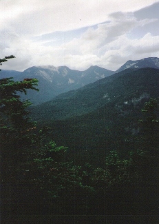
Photo by Dolores
Four Thousand Footers of the White Mountains
| Mountain | Elevation | Date | Comments by Dolores and Dan |
|---|---|---|---|
| Adams | 5774' | 7/6/01 | Shrouded in clouds, 60 MPH winds, 30 degrees F, loop with Madison |
| Bond | 4698' | 9/1/98 | Sunset climb, part of Pemigewasset backpack |
| Bondcliff | 4265' | 9/2/98 | Views just before clouds, part of Pemi backpack |
| Bond, West Peak | 4540' | 9/1/98 | Sunset hike, part of Pemi backpack |
| Cabot | 4170' | 9/14/00 | Wooded, view from lower summit |
| Cannon (Profile) | 4100' | 6/16/01 | Great views of Lafayette, Lincoln and Liberty, peak to ourselves |
| Carrigain | 4700' | 9/6/99 | Clouded in, part of Pemi backpack |
| Carter Dome | 4832' | 8/30/01 | Banner day, close to 80 degrees, part of 1-night backpack |
| Carter, Middle | 4610' | 5/28/98 | No view |
| Carter, South | 4430' | 5/28/98 | Wooded summit, no view |
| Eisenhower (Pleasant) | 4780' | 9/8/00 | Windy but still sunny, part of Presidential backpack |
| Field | 4340' | 8/31/98 | View of Mount Washington and hotel |
| Flume | 4328' | 8/29/01 | Up Osseo Trail, 1-night backpack, great 360-degree views |
| Galehead | 4024' | 9/3/98 | Great views off ledge, part of Pemi backpack |
| Garfield | 4500' | 9/3/98 | Tough climb, great views, part of Pemi backpack |
| Hale | 4054' | 7/21/01 | Sunny and hot, views of Washington, Tom, Field, Willey; bear on I-93! |
| Hancock | 4420' | 8/27/01 | Socked in, no views, part of 1-night backpack |
| Hancock, South Peak | 4319' | 8/27/01 | At least it didn't rain like last aborted attempt |
| Isolation | 4004' | 9/7/98 | High clouds, Washington in fog. Most do this last, not us |
| Jackson | 4052' | 9/7/01 | Friend Winston Wood joined us, as did pesky Canadian jays. Best view of southern Presidentials |
| Jefferson | 5712' | 9/6/00 | Weather and view a gift from God! |
| Kinsman, North Peak | 4293' | 9/11/98 | Great views |
| Kinsman, South Peak | 4358' | 9/11/98 | Great views |
| Lafayette | 5260' | 9/4/98 | Great views but windy |
| Liberty | 4459' | 1/5/00 | Great views, first winter hike! |
| Lincoln | 5089' | 9/4/98 | Great views, part of Pemi backpack |
| Madison | 5367' | 7/6/01 | Socked in, no views, 60 MPH winds, 30 degrees F, loop with Adams |
| Monroe | 5384' | 9/7/00 | Great views, shared peak with "Campfire" |
| Moosilauke | 4802' | 1980s | Hiked various times in 1980s in autumn |
| Moriah | 4049' | 5/27/98 | Sunset |
| Osceola | 4320' | 10/14/00 | Saw Tripyramids, Hancock, Waterville Valley |
| Osceola, East Peak | 4156' | 10/14/00 | Views of Owls Head, snow on Lafayette |
| Owls Head | 4025' | 9/8/99 | Clouded in, part of Pemi backpack, tough to get to |
| Passaconaway | 4043' | 5/29/01 | Wooded summit, views on ledges before peak |
| Pierce (Clinton) | 4310' | 9/7/01 | Great way to celebrate friend Winston's birthday, with wine, views and ascent up peak named after his great-great-great uncle. Post-summit, we dined on trout that Winston caught fly-fishing. |
| Tecumseh | 4003' | 10/9/00 | Late start, view to Tripyramids through trees |
| Tom | 4051' | 8/31/98 | Great view to ourselves, nice bench |
| Tripyramid, Middle Peak | 4140' | 5/31/01 | Snow on last day of May! Part of backpack trip, socked in, no views |
| Tripyramid, North Peak | 4180' | 7/12/01 | Dolores by herself, 7/12/01, Dan by himself, 7/4/00, limited views |
| Twin, North | 4761' | 9/3/98 | Great views, sun out |
| Twin, South | 4902' | 9/2-9/3/98 | Rain and fog first day, views second day |
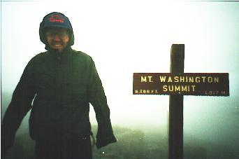
| Washington | 6288' | 9/8/98 | No views, lots of fog, backpacked up |
| Waumbek | 4006' | 9/9/00 | Partial view, better view on Starr King |
| Whiteface | 4020' | 5/30/01 | True summit wooded and no sign, but great views on southern knob |
| Wildcat | 4422' | 9/10/00 | Fog cleared to reveal Carter Notch Hut |
| Wildcat, "D" Peak* | 4070' | 6/1/01 | Spectacular day, lookout tower, view of Washington with snow |
| Willey | 4285' | 8/31/98 | A 1700-foot climb in 1.1 miles with backpack, great views |
| Zealand | 4260' | 9/1/98 | Wooded summit, no views |
| *As of April 1, 2001, Wildcat "D" was the required peak. Before then, either "D" or "E" could have been climbed. | |||

Four Thousand Footers of Maine
| Mountain | Elevation | Date | Comments by Dolores and Dan |
|---|---|---|---|
| Abraham | 4050' | 9/13/99 | Relatively flat first three miles, then steep up. Great view |
| Bigelow, Avery Peak | 4090' | 8/10/93 | Fog, no view, part of Maine AT backpack |
| Bigelow, West Peak | 4145' | 8/9/93 | Rain and fog, part of Maine AT backpack |
| Crocker | 4228' | 8/28/97 | Fogged in, part of Maine AT backpack |
| Crocker, South Peak | 4050' | 9/3/01 | Missed true summit during AT backpack of '97 because of rain; sunny this time |
| Katahdin, Baxter | 5268' | 9/10/92 | Met "Dances with Skunks" and "French Arrow," got lost |
| Katahdin, Hamlin | 4756' | 9/5/01 | Up Hamlin Ridge, high winds, great views, peak to ourselves |
| North Brother | 4151' | 9/6/01 | Windy, sunny, great views of Katahdin, peak to ourselves |
| Old Speck | 4170' | 9/88 | First-ever backpack trip with Dan! |
| Redington* | 4010' | 9/2/01 | Beautiful trail through Caribou Valley; wooded summit with failed windmill energy project |
| Saddleback | 4120' | 8/25/97 | Great 360-degree views, part of Maine AT backpack |
| Saddleback, the Horn | 4041' | 8/25/97 | Spectacular sunset, part of Maine AT backpack |
| Spaulding* | 4010' | 9/1/01 | Skipped spur to summit during AT backpack of '97, back again for ascent on sunny day |
| Sugarloaf | 4250' | 9/12/99 | Day hike up ski trail, great views, late afternoon |
| *As of April 1, 2001, Redington and Spaulding will be required peaks. | |||

Photo by Dolores, 9/2001
Four Thousand Footers of Vermont
| Mountain | Elevation | Date | Comments by Dolores and Dan |
|---|---|---|---|
| Abraham | 4006' | 10/7/01 | Great views of Champlain, foliage and first snow dusting the ridge; COLD! |
| Camels Hump | 4083' | 9/29/01 | Mobbed atop Camels Hump Highway, but at least it was sunny with views |
| Ellen | 4083' | 10/20/01 | Great views of Champlain and Adirondacks at ski lift below wooded peak; we avoid a Ted O'Brien with our headlamps |
| Killington | 4235' | 9/22/01 | First 4,000 Footer in Vermont, sunny, windy, views on last day of summer |
| Mansfield, the Chin | 4393' | 11/3/01 | Turned back by snow last weekend, we succeed this day with great views; but howitzers sounding at nearby military base remind us of the war |
Hundred Highest of New England
| Mountain | Elevation | Date | Comments by Dolores and Dan |
|---|---|---|---|
| Maine | |||
| Abraham, Middle Peak - knocked off official list in April 2001 | 3765' | 9/13/04 | Beautiful views from this remote peak; too bad it was knocked off official list, still worth bushwhacking to |
| Baldpate | 3790' | 9/9/96 | Wind-whipped fog, no views, part of Maine AT backpack |
| Bigelow, North Horn - knocked off official list in April 2001 | 3810' | 9/15/04 | Reclimbed 11 years after initial near-ascent, had skipped side trail during 8/93 rainy backpack; clear skies this time; knocked off official list because not high enough off ridge from South Horn |
| Bigelow, South Horn | 3805' | 8/9/93 | Wooded, part of 70-mile Maine AT backpack |
| Coe | 3795' | 8/30/02 | Part of 9-mile loop, down huge slide, some views before clouds roll in |
| East Kennebago | 3791' | 9/17/04 | Only nice views on logging road, not from peak; cut west on boundary line from logging road, then bushwhacked 0.3 mi, following Papa Bear's great directions |
| Elephant | 3774' | 6/2/05 | Drove logging road to within 1-1/2 miles; not too tough a bushwhack; buggy; wooded summit |
| Fort | 3867' | 9/11/04 | Spectacular views on a glorious day, well worth waiting out the rain and seeing a bit of a "herd" on the herd path; unexpectedly met Papa Bear and Funky Freddy for the first time |
| Goose Eye | 3870' | 9/3/96 | Clear skies and views after Hurricane Edouard cleared out |
| Kennebago Divide, North Peak - added to the official list in April 2001 | 3775' | 8/29/05 | Toasted #100 with a bit of bubbly, sitting under our umbrellas for shelter from the rain. Thanks to all the directions we've gotten along the way from Papa Bear and Audrey, Onestep, Rick and Janis, and Bob and Geri, making the bushwhacks to both #99, White Cap, and #100, relatively painless. Hope to see you in Stratham! Note: Couldn't find the moose antlers. |
| Mahoosuc Arm - knocked off official list in April 2001 | 3790' | 9/4/96 | Steep climb after rough backpack through Mahoosuc Notch |
| Snow (Chain of Ponds Quad) | 3960' | 9/16/04 | Relatively easy 4-mile hike to firetower; surprised to see another hiker who came up from exclusive fly fishing camp on Big Island Pond Road |
| Snow (Little Kennebago Lake Quad)- added to the official list in April 2001 | 3784' | 8/28/05 | Great directions from Rick and Janis off Views from the Top got us safely to the top of Cupsuptic Snow. Rain held off for the most part, although a bit of drizzle up top. Took Burnt Mountain Road to the end, and hiked straight ahead, following some pink ribbons somebody put up, then turned left, again following pink ribbons, onto a herd path. The path took us through a ferny patch, through the spruce and up to the wooded peak. Only about 1.66 miles one way as crow flies. |
| South Brother | 3970' | 8/30/02 | Part of 9-mile loop, views of Katahdin just before clouds roll in |
| White Cap* | 3856' | 8/29/05 | Followed Bear Brook Road all the way up to col, where a cairn marks a herd path to the west, taking us the last 1/4 mile to the peak. Not much of a bushwhack, as bushwhacks go, for #99. On to Kennebago Divide, #100, next, with trusty GPS in hand. |
| Unnamed Peak* - a.k.a. Boundary Peak | 3855' | 5/31/05 | Sun shines through at last atop Boundary Peak, on last day of rainiest May on record; easy hike from Canada along Boundary Swath, thanks to great directions from Papa Bear, via Arm, via Meo, via Ridgerunner! |
| *White Cap (USGS Little Kennebago Lake Quad) and Unnamed Peak (USGS Northwest Pond Quad) are on private land with controlled access. | |||
| New Hampshire | |||
| The Bulge - added to the official list in April 2001 | 3950' | 9/14/00 | Part of backpack to Cabot, Rogers Ledge and the Horn; views east and west through decaying trees; cairn marks peak; hiked this before we knew it was being added to Hundred Highest |
| Cannon Balls, NE Peak | 3769' | 1/6/00 | Second winter hike ever, high clouds but still views |
| Horn | 3905' | 9/13/00 | Part of backpack to Cabot and Rogers Ledge, great views |
| Nancy | 3926' | 5/26/04 | Herd path up top makes it easier, but still steep |
| Sandwich | 3980' | 7/14/01 | Good views of Whiteface, Chocorua and Tripyramids |
| Scar Ridge, West Peak | 3774' | 5/23/04 | Tough bushwhack over 2 days |
| Sleepers, East Peak | 3860' | 5/30/01 | Part of backpack to Tripyramids; wooded |
| Vose Spur | 3862' | 9/6/04 | Tricky herd path, hard to find and easy to lose; very steep, no views; our new GPS came in handy when we lost herd path at night |
| Weeks, North Peak | 3901' | 8/20/02 | Part of 4-day backpack of section of new Cohos Trail, wooded summit |
| Weeks, South Peak | 3885' | 8/19/02 | Part of 4-day backpack of section of new Cohos Trail, wooded summit, camped here |
| Unnamed Peak** - a.k.a. Peak above the Nubble | 3813' | 5/29/05 | Hailstorm, thunder and lightning greet us atop the peak; tough bushwhack through dense blowdown; luckily met Arm and companion, who told us to go down via slide (a.k.a. waterfall), saving us at least an hour on descent. |
| **Located north of North Twin, southeast of Haystack (USGS South Twin Mountain Quad). | |||
| Vermont | |||
| Big Jay | 3786' | 8/29/03 | Wooded summit marked by canister and reached by newly carved unmarked trail; light rain |
| Bread Loaf | 3835' | 8/28/03 | Unmarked wooded peak; spur provides views of Lake Champlain and Adirondacks |
| Dorset Peak | 3770' | 8/24/03 | Easy logging road, but could pass 2nd cairn and turn L at doorknobs(!), to skip false summit w/partial view and go directly to true summit w/no view, except of old cabin and Eugene Daniell's and Tom Sawyer's memorial pitchers(!) |
| Equinox | 3850' | 6/5/02 | First we paid $8 and drove up toll road; then we hiked up next day, to views of mountains and shuttered motel at top |
| Jay Peak | 3858' | 8/29/03 | High clouds and windy, joined at the peak by tourists who came up ski tram; saw Big Jay in distance |
| Mendon Peak | 3840' | 8/25/03 | Tough bushwhack after turning off old logging road at height of land, past second cairn where most people head into woods, as some had suggested; ended up too far southeast, then couldn't backtrack to road, yet miraculously found herd path in col between twin peaks after a couple of hours wandering with compass; no views on true summit |
| Pico Peak | 3957' | 8/27/03 | Nice views of Killington and Ascutney, as long as you look past the Pico ski lift; nice chat with Green Mountain Club volunteer too |
| Stratton | 3940' | 6/3/02 | Amazing views from firetower, to as far as the Blue Hills in Mass. and Presidentials in New Hampshire; this is where the Long Trail and Appalachian Trail were conceived |
| Wilson | 3790' | 6/7/02 | We did this peak as part of a two-night backpack, and were rewarded with great views of Killington from spur trail |

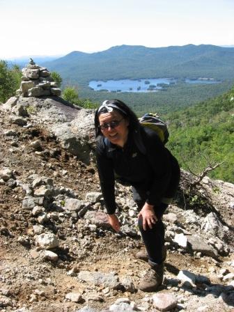
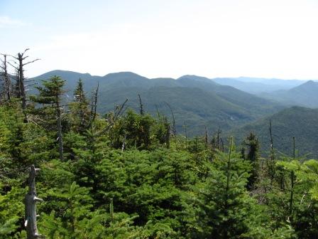
A view into the heart of the Adirondacks, on the road to the Loj
46Rs and Hundred Highest in the Adirondacks
| Mountain | Elevation | Date | Comments by Dolores and Dan |
|---|---|---|---|
| Mt. Marcy | 5344' | 8/31/06 | Left base camp shortly after 9 a.m. to avoid the Marcy traffic jam, and got to peak after a not-too-difficult 4.4-mile hike, reaching summit at about noon. Only a handful of hikers on clearest day of 2-week trip, with tremendous views, good info from Summit Steward Hannah and nice chat with software engineer originally from Burlington, Vt., but now living in Boston. (Ran into Summit Steward Hannah again on Phelps Trail, on our way out from 4-night trip in August 2007, after bagging Saddleback, Basin and Haystack.) |
| Algonquin Peak | 5114' | 5/29/07 | Best day of the vacation. A nine-hour hike, between 10 and 11 miles roundtrip over Algonquin, #2 in height, and also Iroquois, #8. A 912-foot climb in 0.9 mile to reach Algonquin, one of the steepest climbs in the High Peaks. We ate my Mom's traditional Chinese meal, "gaw doong tee," the first time over Algonquin, and saw a peregrine falcon on our return trip back from Iroquois. |
| Mt. Haystack | 4960' | 8/28/07 | You can see why the 46Rs officially rate Haystack as having the No. 1 view, when you climb this third highest ADK peak on a crystal-clear day as we did. There are breathtaking vistas of the Marcy Cliffs across Panther Gorge and all around, over to Basin and the rest of the Great Range. And we enjoyed spending some time with Robert Johnson, a pediatrician, raconteur and a leader for the Tidewater Council Boy Scout Troop 70, of Norfolk, Va., and his group, atop the summit. He was kind enough to take our picture. Haystack humbles, not only by showing the grandeur of nature and smallness of mankind, but also by its ruggedness, as Dolores found out when she tripped on a root on her way down, badly bruising her knee. Haystack and the rest of the Adirondacks are not to be underestimated. And don't count on cell phone reception atop Haystack, either, whether in case of emergency, or to try to hook up with a friend, as we unfortunately found out when we tried to reach our friend Winston Wood, who was hiking Mansfield that same day. From Haystack we could see Mansfield, but we couldn't call or text message over there. Sorry we missed you Winston! |
| Mt. Skylight | 4926' | 8/31/06 | Arguably one of the best 360-degree views of the Adirondacks, of up to 30 peaks. Tremendous weather, short hike from Marcy. Summit to ourselves, and had artisan-crafted champagne cheddar cheese and crackers to celebrate. Too bad camera battery died; not sure if one photo taken atop Skylight is going to come out. |
| Whiteface Mtn. | 4867' | 8/21/06 | Clouds burned off, allowing great views on the climb up an arete (sharp glacier-produced ridge) and to the summit. Crowds that drove up and took elevator to top couldn't take away from peak experience. First climb of 2-week trip, after ending previous trip atop nearby Esther, in a nice symmetry. Later attempt to drive up Whiteface Memorial Highway unsuccessful with gate closed by 5 p.m., but that led us to see our only black bear of the trip, clocked running 35 MPH along the road! |
| Dix Mtn. | 4857' | 8/23/07, 8/27/08 | Long 6.8-mile day hike in from Route 73 to socked-in summit with no views in 2007, but we did see closed gentian and red salamander on the way out, and late-day clearing on the way down Dix slide, enough to catch a view of Noonmark. We were determined to redo Dix for its panoramic views when we bushwhacked nearby Hough on a beautiful day in 2008, and were we glad we did. The herd path along the ridge from Hough to Dix took our breath away, especially the last scramble up the Beckhorn of Dix. The long loop down Dix and back to our campsite led us by peaceful Dix Pond. |
| Gray Peak | 4840' | 8/31/06 | Reluctant to end too early such a beautiful day of hiking, we tag on Gray Peak after Marcy and Skylight, for a 3-peak-bagging experience, our first in the Adirondacks. Tough scramble, view to ourselves of Marcy, Skylight and others. Did the 13-mile loop in 12 hours, back to camp site with head lamps. |
| Iroquois Peak | 4840' | 5/29/07 | Reminded us of our trip to Skylight and Marcy, the way Iroquois relates to Algonquin, the solitude, the 360-degree views and the weather. Thick conifer in the sag between the two mountains. Great views over Colden Lake. Had Iroquois to ourselves. |
| Basin Mtn. | 4827' | 8/27/07 | Another grand day in the Adirondacks. Part of 4-night trip into Johns Brook Lodge area as base camp. We avoided the notoriously steep cliff climb between Saddleback and Basin by hiking them separately, rather than as part of a loop. Saw three black bears near the lodge on the way back to our campsite in the evening. There's a good reason for bear canisters, although we heard on the trail that at least one bear in the area has figured out how to break into a canister. |
| Gothics | 4736' | 8/20/07 | Sweeping 360-degree views, and some of the steepest, longest rock face we've ever seen. Glad we went down the steep west face with its cable, rather than up it. Dolores did a bit of butt sliding too. |
| Mt. Colden | 4714' | 5/28/08 | A 6-mile one-way climb from Adirondack Loj to Mt. Colden brought us by Marcy Dam, along Arnold Lake, over patches of snow and under a precariously balanced set of rocks, which Dolores points to here. Little does she know that half an hour later, she'd be scrambling through those rocks, counting her blessings that the ice underneath has melted somewhat. |
| Giant Mtn. | 4627' | 5/25/06 | Tough climb but worth the effort on one of only two sunny days this trip. Views of Dial, Nippletop and Wolf Jaws. Decided not to do Rocky Peak Ridge this time, so could enjoy the scenery. Dan looked down upon low-flying fighter planes. |
| Nippletop | 4620' | 8/23/06 | One of best Adirondack views according to the Marshall brothers, said the hiker from Rochester, NY, we met atop Nippletop. Saw Camels Hump and Lake Champlain, and great views of the Great Range and distinctive Snowy Mountain. |
| Santanoni Peak | 4607' | 5/26/09 | We're glad we added on Santanoni to the tail-end of an already-long hike, because it would have been psychologically and physically tough to climb back up the ridge for this peak alone. As it was, climbing the three false summits to Santanoni, after having already scaled Panther and Couchsachraga, was tough enough. But we were rewarded with views to the Great Range, Indian Pass and Wallface, and solitude. |
| Mt. Redfield | 4606' | 8/27/09 | A glorious way to finish the 46Rs and Northeast 111ers, atop Redfield with its wilderness views of the Great Range, and a unique perspective on the way up, with a framed view of Iroquois and Algonquin from a terraced pool on Uphill Brook. It seems only fitting that our last 46R would entail our longest Adirondack day hike, 17 miles and 12 hours round-trip; feature an up-close view of Allen, where we began this two-week trip; and end with a moonlit view of Marcy Dam and owls calling in the darkness, a poetic close to this latest chapter in our hiking career. The timing couldn't have been more perfect either, in terms of weather, or getting off the trail just in time to place the last takeout order to Mr. Mike's in Lake Placid via cell phone at 10:30 p.m., the moment we got a signal along the road out of Adirondack Loj. |
| Wright Peak | 4580' | 5/23/06, 8/31/07 (Dan alone) | The snow that put Lake Placid on the national news didn't deter us from bagging Wright in May 2006. No High Peaks views, however, just wind-whipped high clouds. Dolores did crab-like crawl to get over slipperiest rock face above tree line. Dan builds snow cairns to show Dolores the way. Weather too threatening in May 2006 to find memorial to the four airmen who crashed into Wright decades ago. But in August 2007, on a glorious day, when Dan reclimbed for the views, while Dolores recovered from Haystack, he was honored to run into Peter Fish, retired forest ranger, and his friend the University of Michigan biologist. Peter took Dan to the memorial and remnants of the plane crash, off the beaten path. |
| Saddleback Mtn. | 4515' | 8/26/07 | When the low clouds blow off, intermittent views of the Great Range, particularly an in-your-face perspective of Basin. The wetness of the day persuades us not to try to risk climbing down the precipitous cliffs and do a loop over Basin. Glad we made that decision, especially when we see from Basin the next day how precipitous those cliffs are. |
| Panther Peak | 4442' | 5/26/09 | Less than half a mile from "Times Square," as the meeting point of three herd paths on the Santanoni ridge is called, Panther offers arguably the best views from the three 46Rs off this ridge. It took us 13 hours to go the 10 miles up and over Panther, Couchsachraga and Santanoni. |
| Table Top Mtn. | 4427' | 8/30/06 | Backpacked in 3 miles to second base camp of trip for a 2-night stay. Hiked up Table Top same afternoon. Less steep than Phelps with marked "herd path." Views of Marcy and Algonquin. |
| Rocky Peak Ridge | 4420' | 5/28/07 | Great views of back side of Giant. An 8.6-mile roundtrip; steep descent off Giant and then ascent to Rocky Peak Ridge 1.3 mile one way. Part of mop-up hiking, since we could have done this when we did Giant last year. |
| Macomb Mtn. | 4405' | 8/26/08 | A herd path and steep slide climb bring us to the top of Macomb, where we meet a family from Greenwich Village who've been vacationing at Elk Lake Lodge for years, and who graciously take our photo. We feel fortunate to have glorious weather, after one of the wettest summers on record in the Adirondacks, with rain every day over the course of a few weeks in July and August. |
| Armstrong Mtn. | 4400' | 8/20/07 | Part of 3-peak loop, including Upper Wolf Jaw and Gothics. High clouds allow nice views of the Wolf Jaws. We also saw a bird of prey circling above the summit. One particularly challenging rockface climb, at least for Dolores. |
| Hough Peak | 4400' | 8/27/08 | Up the recently cleared Lillian Brook herd path, past a bivouac campsite and up and over the hogback (also known as Pough, as in huff-and-puff), we reach Hough with its dramatic views of Dix's Beckhorn. In the small-world category: We run into Brian and Karen Delaney, owners of High Peaks Cyclery in Lake Placid, where we had bought a pair of gaiters a few days earlier, to protect against the mud so prevalent this hiking season. |
| Seward Mtn. | 4361' | 8/25/09 | Glad we ran into a solo hiker a couple of days earlier suggesting the more gradual Calkins Brook herd path up this penultimate 46R, rather than the more traditional path near Bluberry Lean-to. Of the three peaks on this ridge, we did Seward last, climbing a couple of amazing rock faces to get to the summit. And we're glad we were able to make it back to the camp site before it got too dark (11 hours to complete 10 miles), especially since Dolores's head lamp was broken. There was time for Dan to enjoy a refreshing body shower too. |
| Mt. Marshall | 4360' | 8/22/08 | Herbert Brook and closed gentian and bunchberries are among the sights you can see along the amazing watery slide climb up Marshall. |
| Allen Mtn. | 4340' | 8/17/09 | The ford across the Opalescent wasn't as bad as feared, although the herd path up Allen was as long and steep as anticipated. We headed straight to the trailhead from Massachusetts, planning a two-night backpack to start our traditional two-week August vacation. We'd heard that author Bill McKibben had adopted this trail, and that he and his daughter had recently climbed Allen in their quest for the 46Rs, but we didn't see him this trip. We got the summit to ourselves, with its glimpse into Panther Gorge and surrounding environs. |
| Big Slide Mtn. | 4240' | 5/24/06 | Sun at last! Great views from Brothers on way up to Big Slide, and atop Big Slide itself, of Great Range, Giant, Wolf Jaws and Sawteeth. |
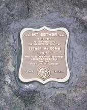
| Esther Mtn. | 4240' | 5/26/06 | Slight drizzle, no views up top, except for glimpse of Whiteface between clouds. Plaque commemorating indomitable spirit of 15-year-old Esther McComb, who made first recorded climb in 1839 out of the sheer joy of climbing (plus she also got lost on the way to Whiteface). |
| Upper Wolf Jaw Mtn. | 4185' | 8/20/07 | First 46R peak of the August 2007 trip, part of a 3-peak day hike and 2-night backpack. High clouds allowed good views, including of Lake Champlain, from boulder peak, a spur off the main trail. |
| Lower Wolf Jaw Mtn. | 4175' | 8/21/07 | Limited but good views of Big Slide, Armstrong and Gothics. Shared the summit with a couple of other parties. Tagged this peak before we headed out after 2 days in the woods, including the 3-peak Great Range mini-traverse the day before. |
| Street Mtn. | 4166' | 8/26/06 | Clearing a little below summit allows view of Algonquin under sunny skies. Summit to ourselves, until religious party arrives. |
| Phelps Mtn. | 4161' | 8/28/06 | Dan beat 2 women to top who were faster, taller and younger than Dolores. They had an interesting conversation. Great views of Marcy and Algonquin from rock face. |
| Mt. Donaldson | 4140' | 8/25/09 | Of the three summits on this ridge, Donaldson has the best views, including one of the much-higher Seward to the north and Seymour to the east. It's easy to miss the actual peak if you're not careful. You have to climb up a rock face on the east side of the herd path and find the yellow trail marker labeled "Donaldson." The Calkins Brook herd path brings you up the col about 0.2 miles north of Donaldson. |
| Seymour Mtn. | 4120' | 8/24/09 | We couldn't wait on the weather any longer, after having done only one 46R, Allen, in the whole first week of vacation. The forecast called for possible thunderstorms the day we decided to backpack in for the four peaks of the Seward range, but we didn't expect heavy downpours throughout the evening and into the next morning. Luckily, we got Blueberry Lean-to all to ourselves and stayed dry. And luckily, Seymour as a stand-alone peak wasn't as far as feared, allowing us to start as late as noon and still have time to hike over to the Calkins Brook herd path for the easier route up the rest of the Sewards the next day. Clouds starting rolling in after we scaled Seymour, but we sneaked in views of the Santanonis. |
| Sawteeth | 4100' | 8/24/06 | Last hike of 3-nighter. Stopped at nearly 150-feet high Rainbow Falls first, near the Weld Trail (relative of former Mass. Gov. Bill Weld's?) approach to Sawteeth. Tough 1.6 mile up Weld, then 500 feet elevation gain in another 0.5 mile to Sawteeth. In-your-face views of Pyramid and Gothics from Sawteeth, then clouds and rain forcing us off. |
| Cascade Mtn. | 4098' | 9/3/03 | We didn't see a damned thing, it was so socked in, but we got solitude as a result on this easiest 4000 Footer in the Adirondacks |
| South Dix | 4060' | 8/26/08 | Indian pipes can be found in the woods of South Dix. |
| Porter Mtn. | 4059' | 9/3/03 | Peak-bagger's rule is to do the nearby summit even if socked in, so we hiked the extra mile from Cascade to this mountain |
| Mt. Colvin | 4057' | 8/22/06 | Backpacked in over 4 miles to set up base camp above Indian Head and beyond the AuSable Club boundary. Tagged Colvin on same day. Good view of Blake, which we regret not climbing on the same trip, and of Sawteeth and Gothics. |
| Mt. Emmons | 4040' | 8/25/09 | We share a laugh, the view from Emmons and a Red Bull moment with the Eckert-Delarm family from Paul Smiths. Emmons was our 44th peak, and it was Sheila and Hannah's 41st. This photo of us by Sheila Delarm shows Seward in the background. Hope to see Sheila, Bob, Hannah and Luke at the 46Rs ceremony in May 2010! The mile between Donaldson and Emmons was dotted with boot-sucking mud, even in August. And yes, Emmons really is that far-away peak, and not the false summit right after Donaldson. It was a long mud-slog back over Donaldson, but we had to do that to get to Seward, and to get back down the Calkins Brook herd path. We hear that some hikers will break up the three peaks as separate hikes, with Seward by itself, and the easier Donaldson and Emmons together. |
| Dial Mtn. | 4020' | 8/23/06 | Went on to Dial after Nippletop, when a hiker told us it was "flat" between Dial and Nippletop. Summit to ourselves, enjoying view from rock face. High clouds. Nice to do two 46Rs same day, after regretting not having done Blake with Colvin, and Rocky Peak Ridge with Giant. |
| East Dix | 4012' | 8/26/08 | Had to go over Macomb and South Dix first before reaching East Dix. A petition is afoot to rename East Dix after the late Grace Hudowalski, long-time Adirondack 46Rs historian. |
| Blake Peak* | 3960' | 6/1/07 | Backpacked about four miles into Indian Head the day before, arriving early, about 5 p.m., and enjoyed late afternoon sun in tent with tent fly down. No rain. Bugs not a problem. About six miles round trip from tent site to Blake. Great views of Ausable Club. Had to reclimb Colvin twice to get to Blake, steep ups and downs. Backpacked out same day, total of 10 miles for the day. |
| Cliff Mtn.* | 3960' | 8/21/08 | On the way to Cliff, we get this view of Avalanche Pass. And up top, you have to go up and over a false summit, before you arrive at the true summit with its sign. |
| Nye Mtn.* | 3895' | 8/26/06 | Herd path to Street and Nye not too crowded, even on a sunny Saturday. Had Nye to ourselves, viewless as it was. But there was a sign marking the top. |
| Couchsachraga Peak* | 3820' | 5/26/09 | From Panther, Couchsachraga looks significantly lower than even the Santanoni ridge. So how could Bob and George Marshall have thought this peak was 4000 feet or higher? But to be an official 46R, you have to bushwhack over to this peak as part of an extended three-peak hike, no complaining allowed. Instead, enjoy the solitude, and the rarely seen views. Water in a bog at the base of Couchie saved us on this otherwise dry ridge, allowing us to go on to Santanoni. |
| MacNaughton Mtn. | 4000' | - | - |
| Green Mtn. | 3980' | - | - |
| Unnamed Peak(Lost Pond) | 3900' | - | - |
| Moose Mtn. | 3899' | 8/22/07 | Nice views of Lake Placid and Saranac Lake. Also views of Whiteface and McKenzie Wilderness. Lots of blowdowns on the trail, some serious. Trail maintained by Shore Owners Association, but more like a herd path in some spots. Lots of solitude, saw only one other hiker the whole day. |
| Snowy Mtn. | 3899' | - | - |
| Kilburn Mtn. | 3892' | - | - |
| Sawtooth Mtns. (No. 1) | 3877' | - | - |
| Panther Mtn. | 3865' | - | - |
| McKenzie Mtn. | 3861' | 9/4/03 | Great views of Lake Placid on the east and Saranac Lake on the west, from ledges on the fifth peak, which is true summit; tough 1,000-feet climb in just over half mile |
| Blue Ridge | 3860' | - | - |
| North River Mtn. | 3860' | - | - |
| Sentinel Mtn. | 3838' | - | - |
| Lyon Mtn. | 3830' | 8/19/09 | The recent rerouting of the trail makes it a more gradual climb up to this summit with a fire tower. You can see windmills in the distance and, on a clear day, skyscrapers in Montreal. We originally didn't plan on doing Lyon as part of the Fire Tower Challenge (you can opt out of a few on the list), but once we realized it's also one of the 100 Highest in the Adirondacks, and the trail was recently rerouted, we put it back on our list. We were pleasantly surprised to find the cabin of the fire tower open, since Jack Freeman's book lists the Lyon fire tower as one that may not last. |
| Sawtooth Mtns. (No. 2) | 3820' | - | - |
| TR Mtn. | 3820' | - | - |
| Averill Peak | 3810' | - | - |
| Avalanche Mtn. | 3800' | - | - |
| Buell Mtn. | 3786' | - | - |
| Boreas Mtn. | 3776' | - | - |
| Blue Mtn. | 3760' | - | - |
| Wakely Mtn. | 3760' | - | - |
| Henderson Mtn. | 3752' | - | - |
| Lewey Mtn. | 3742' | - | - |
| Sawtooth Mtns. (No. 3) | 3700' | - | - |
| Wallface Mtn. | 3700' | - | - |
| Hurricane Mtn. | 3694' | 9/2/03 | Made out Crow Mountains, which we had climbed the day before, from below the high clouds; but rest of what's supposed to be great views not visible; abandoned fire tower up top |
| Hoffman Mtn. | 3693' | - | - |
| Cheney Cobble | 3683' | - | - |
| Calamity Mtn. | 3620' | - | - |
| Little Moose Mtn. | 3620' | - | - |
| Sunrise Mtn. | 3614' | - | - |
| Stewart Mtn. | 3602' | - | - |
| Jay Mtns. | 3600' | - | - |
| Pitchoff Mtn. | 3600' | 9/1/06 | Ended the vacation with 1 more peak, even though we'd just backpacked out 3 miles after a 2-nighter and 13-mile hike over Marcy, Skylight and Gray. Late-day hike to minimize crowds on Friday, start of Labor Day weekend. Views of Cascade and Porter below the high clouds. |
| Saddleback Mtn. | 3600' | - | - |
| Pillsbury Mtn. | 3597' | - | - |
| Slide Mtn. | 3584' | - | - |
| Gore Mtn. | 3583' | - | - |
| Dun Brook Mtn. | 3580' | - | - |
| Noonmark Mtn. | 3556' | 5/30/07 | Steep hike up to peak. Eventually had it all to ourselves. Pictures of Dolores under peak on return trip. 360-degree views. Five miles round trip. |
| Mt. Adams | 3540' | 5/30/08 | Unlike the hike the day before, up Mt. Jo, where for surprisingly little effort, you get magnificent views, Mt. Adams rewards you with little view after a lot of effort. The more than 1,000 feet elevation gain in less than a mile near the summit is among the steepest pitches we've climbed. The fire tower is closed because of extensive wind damage. You can see the sheared-off roof and windows lying at the base of the tower. But between the trees, you can still see Calamity Mountain, Colden, Algonquin, Iroquois and Marcy. And you can enjoy the wildflowers along the trail in spring. |
| Fishing Brook Mtn. | 3540' | - | - |
| Little Santanoni Mtn. | 3500' | - | - |
| Blue Ridge | 3497' | - | - |
| Unnamed Peak (Fishing Brook Range) | 3480' | - | - |
| Puffer Mtn. | 3472' | - | - |
| Sawtooth Mtns. (No. 4) | 3460' | - | - |
| Sawtooth Mtns. (No. 5) | 3460' | - | - |
| Wolf Pond Mtn. | 3460' | - | - |
| Cellar Mtn. | 3447' | - | - |
| Blue Ridge Mtn. | 3440' | - | - |
| Morgan Mtn. | 3440' | - | - |
| Blue Ridge | 3436' | - | - |
| Unnamed Peak (Brown Pond) | 3425' | - | - |
| *Four of the highest 46 peaks are listed slightly out of elevation order, to stay true to the original list of the Adirondack Forty-Sixers Club. The original 46 were all thought to be 4000 feet or higher in the early 1900s, but subsequent surveys found some to be lower. To become a member of the club, you need to climb the original 46. | |||

Peak to Peak Trail and Wilderness Links
Last modified: June 16, 2013